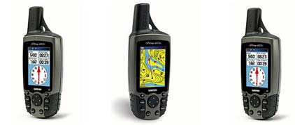
GPSMAP 60CSx
The GPSMAP 60CSx adds several performance-enhancing features to the popular 60-series products, including a removable microSDT card, high-sensitivity GPS receiver, barometric altimeter and electronic compass.
Pinpoint Your Location - and Direction
With the GPSMAP 60CSx, you can find your way in almost any conditions:
High-sensitivity GPS receiver gives you improved satellite reception even in heavy tree cover or deep canyons
Barometric altimeter provides extremely accurate elevation data
Electronic compass can determine your heading and direction, even when you're standing still
IPX7 waterproof case can withstand an accidental dunk in the water and still perform
Large, color TFT display makes viewing the screen easy, day or night
Built-in Americas autoroute basemap, including highways, exits and tide data, gives you automatic, turn-by-turn directions
Add More Detail
The 60CSx comes with a blank 64 megabyte (MB) microSD card, so you can store extra maps from optional MapSource® mapping software. Just connect to your computer with the USB cable, and you can load map data or transfer routes and waypoints. You can even purchase microSD cards that are preloaded with MapSource maps, which means you don't have to connect to your computer. The microSD card slot is located inside the waterproof battery compartment, so you never have to worry about water getting inside.
GPSMAP 60CSx: Put the great outdoors in the palm of your hand
Physical & Performance
| Unit dimensions, WxHxD: | 2.4" x 6.1" x 1.3" (6.1 x 15.5 x 3.3 cm) |
| Display size, WxH: | 1.5" x 2.2" (3.8 x 5.6 cm) |
| Display resolution, WxH: | 160 x 240 pixels |
| Display type: | 256 level color TFT |
| Weight: | 7.5 oz (213 g) with batteries |
| Battery: | 2 AA batteries (not included) s |
| Battery life: | 18 hours, typical |
| Waterproof: | yes (IPX7) |
| Floats: | no |
| High-sensitivity receiver: | serial and USB |
| Interface: | yes |
| RoHS version available: | yes |
Maps & Memory
| Basemap: | yes |
| Preloaded street maps: | no |
| Ability to add maps: | yes |
| Built-in memory: | no |
| Accepts data cards: | 64 MB microSDT card (included) |
| Waypoints/favorites/locations: | 1000 |
| Routes: | 50 |
| Track log: | 10,000 points, 20 saved tracks |
Features
| Automatic routing (turn by turn routing on roads): | yes |
| Electronic compass: | yes |
| Touchscreen: | yes |
| Barometric altimeter: | yes |
| Geocaching-friendly: | yes |
| Outdoor GPS games: | yes |
| Hunt/fish calendar: | yes |
| Sun and moon information: | yes |
| Tide tables: | no |
| Area calculation: | yes |
| Custom POIs (ability to add additional points of interest): | yes |
| Unit-to-unit transfer (shares data wirelessly with similar units): | no |
| Picture viewer: | no |
Copyright © 1996-2010 varun. or its subsidiaries